Identifying the Systems
This case from 22 April 2015 lets you practice identifying fog and low clouds in satellite imagery. The day microphysics, night microphysics, and day natural colour RGBs are particularly useful for detecting low-level stratus, stratocumulus cloud, advection, and radiation fog.
View the animations in the tabs, then answer the question below.
Question
What systems dominate the weather in areas A, B and C on 22 April 2015 at 0200 UTC? (Use the selection box to choose the answer that best completes the statement.)
The correct answers appear below the choices in green.
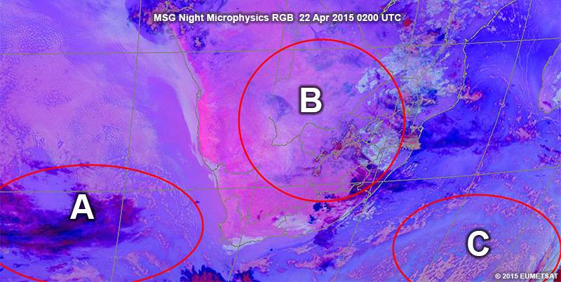
Area A is a high pressure system over the Atlantic Ocean. The presence of stratocumulus cloud and the slow movement of the cloud in the animations shows that anti-cyclonic rotation is occurring.
Area B is a high pressure system over the southern parts of Africa. The clear skies and cloud-free environment are a testament to this.
Area C is a low pressure system. In fact, it is a cold front that's moving away to the south-east. In the animations, you can see the cold air cumulus cloud moving up from the south with a slight cyclonic rotation.
Looking at the night microphysical animation below, the cold air cumulus presents as pale pink clouds over the southern part of the Indian Ocean, south-east of South Africa. These clouds move in a cyclonic fashion with time. They have fairly warm cloud top temperatures and there's a small possibility of rain or light showers accompanying them. The cold front found ahead/east of this cold air cumulus is depicted by the deep precipitating red cloud band in the far south-east part of the image.