Stratus/Fog or Stratocumulus
Question
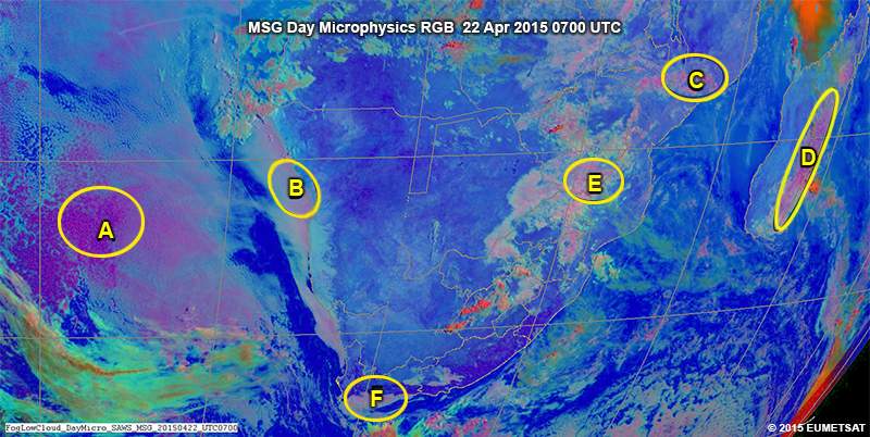
Examine this image from 22 April 0700 UTC and decide if each area is experiencing stratus/fog or stratocumulus. (Use the selection box to choose the answer that best completes the statement.)
Area A has stratocumulus cloud. This cloud type is found in a stable environment and is mostly associated with high pressure systems. It is a water cloud and has a positive cloud top temperature. Its rough texture separates it from stratus.
Area B has stratus or fog. This is a warm water cloud, with a smooth/homogenous texture. The pink colour coming through is due to the increased thickness in several places. The fog/stratus follows the contour of the coastline closely.
Areas C and D have stratocumulus that may be precipitating. The stratocumulus is thicker than the cloud seen in area A and has a more cellular structure as well. If local ground observations are available, they may be reporting rain or light showers.
Area E has stratocumulus, which is not precipitating. This cloud also has a similar cellular structure to that seen in areas C and D but is not as thick. The cloud top temperatures are warm, and it’s a water cloud.
Area F has stratus/fog. This is a smooth, fairly thick water cloud, which has encroached over the coastline. It’s following the contours of area’s topography where the mountain rise quite steeply to over 3000 ft.
As you can tell, it's difficult to distinguish between fog and stratus in single images. You really need an animation of the previous few hours to see where and when the cloud formed. Both stratus and fog look the same on satellite imagery although fog can often be thicker and appear more pink in the day natural colour RGB.