
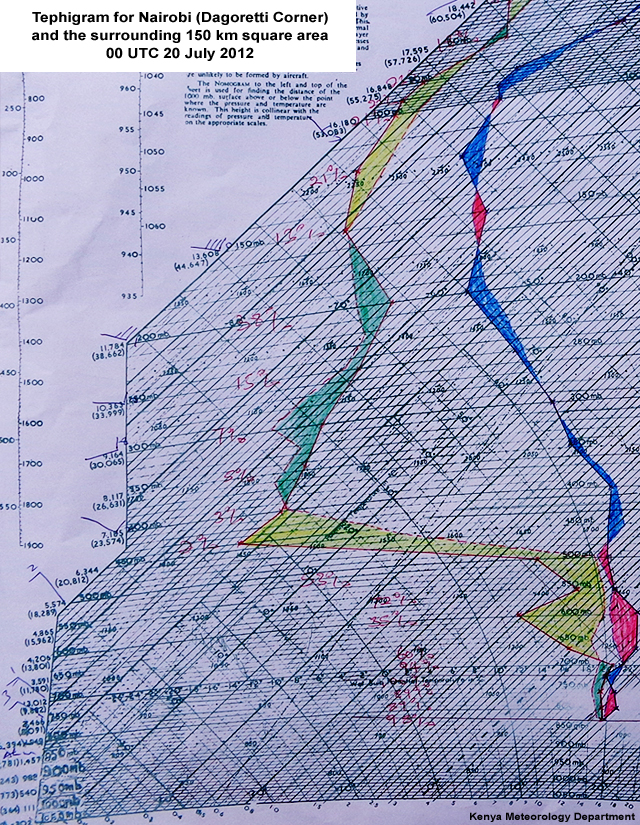
Sounding
Here's the sounding for Nairobi (Dagoretti Corner) at 00 UTC 20 July. Click the tabs to study both views, then answer the questions below.
Plotted Tephi
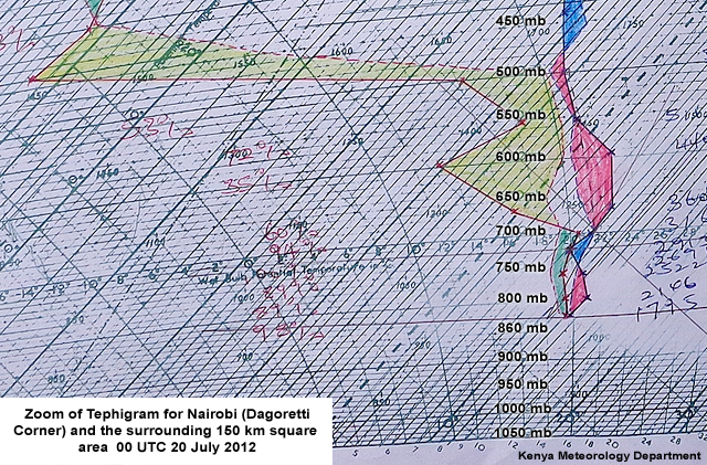
Plotted Tephi Close Up
Question 1: What are conditions in the upper troposphere between 700 and 300 hPa? Select the correct option.
The correct answer is D.
Conditions above 700 hPa are considerably drier than in the lower atmosphere. A wind shift occurs around 400 hPa but it goes from generally northwest to generally southeast above that level, making A incorrect. B is wrong because the dew point depression increases considerably above 700 hPa, indicating that clouds are not present above that level. Winds in the upper levels are stronger than seen below 700 hPa, making C incorrect.
Question 2: Are there any indications of cloud below 300 hPa? If so, choose the right level.
The correct answer is B.
The temperature and dew point lines are close enough to indicate clouds in the layer between 750 and 700 hPa.
Question 3: How would you characterize the lower atmosphere? Select the option(s) that apply, then click Done.
The correct answers are A and C.
The stable layer between 720 hPa and 690 hPa is acting to decouple the lower levels of the atmosphere from the levels above. Air below is closer to saturation and the saturated layer corresponds to the level of the observed stratus clouds. A surface-based inversion is developing because the surface is cooling more rapidly that the air above it, making B incorrect. The winds in the stable layer are lighter than those seen above, making D wrong as well.
Question 4: How would you expect the conditions to affect the stratus that formed at 00 UTC? Select the option(s) that apply, then click Done.
The correct answers are C and D.
The stability and moisture at low levels, calm winds, and dry air above the stratus will all work together to maintain and perhaps deepen the cloud layer overnight. Since the winds are relatively weak in the layer near the surface, which is stable overall, A and B are incorrect.
Radiative heat loss is maximized when the layer immediately above the fog or low clouds is relatively dry, the winds are weak, and there are no cloud layers aloft. On a clear night, the rate of fog-top radiational heat loss is much more rapid than that in the lowest few meters of the atmosphere, which can result in thickening of the cloud layer.