

Upper level lows are closed cyclonically circulating eddies. Colder air is involved in the upper level low than in the surroundings (compare typical appearance in vertical cross section), which develop in the upper- and mid-levels of the troposphere. The scale of the upper level low is generally smaller than that of extratropical cyclones during its mature stage. This cyclonic circulation is the consequence of its own life cycle and in the end stage is isolated from the main western stream. As these lows are only upper and mid-tropospheric features, they do not have a corresponding low within the lower levels of the troposphere, at least in the beginning (compare key parameters).
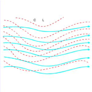
The development of an upper level low depends on the existence of unstable waves within the general flow in the upper levels of the troposphere. A characteristic feature for these unstable waves is the temperature wave (red dashed lines) being situated behind the potential wave (cyan solid lines). Due to this phase shift, two characteristic features can be observed:
|
|
|
|
Upper Level Trough:
The assumption for the development of an upper level trough is unstable
potential waves within this layer of the troposphere. As already described above,
the temperature field is characterized by the temperature wave being situated
behind the potential wave. Therefore CA can be found within the area of the
upper level trough. During this stage of development the field of the absolute
topography is characterized by an increase of the amplitude of the potential
wave and sometimes also by a decrease of the wavelength. The same development
takes place for the temperature wave. In the northern hemisphere a southward
deviation of the isohypses and isotherms of the upper level trough can be
observed leading to a deepening of the trough.
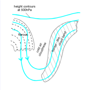
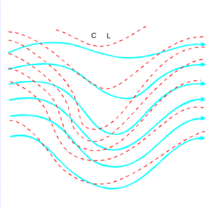
This stage of development is characterized by the development of an inverse
omega-shape of the isohypses within the mid-levels of the troposphere (for
instance within the height field at 500 hPa). The main meteorological process
during this stage involves the trough starting to detach from the meridional
stream. As a consequence of the further increase in the amplitude of the waves
(further deepening of the trough) the cold air from the north streaming to
southern regions will be cut from the general polar flow and the warm air from the
south streaming to northern regions will be cut from the general subtropical flow.
The consequence of this process is the development of a cold upper level low within
the southern part of the trough. The circulation of the low is characterized by
closed isohypses and an eddy in the wind field at 500 hPa. But as this low is
within its initial stage and therefore only weak, the main upper level flow
still follows the inverse omega shape of the isohypses.
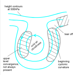
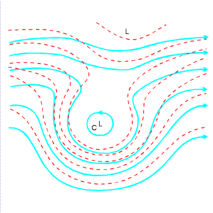
In contrast to the previous stage, the tie-off is finished and the upper level
low is now much more pronounced. The wind field at 500 hPa shows a well-developed
closed circulation in the area of the former trough which in the ideal case is
cut off from the general meridional flow.
|
|
|
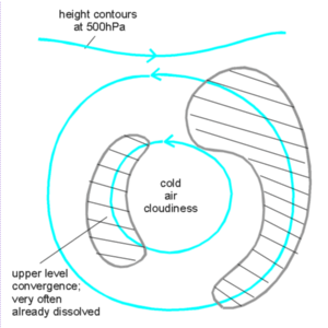
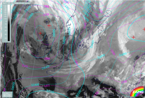
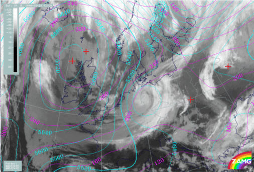
The images above show the life cycle of an upper level low. The first image (left image top) shows the upper level trough stage, the second image (right image top) the tear-off stage and the third image (left image bottom) the cut-off stage.
The change of temperature during the cut-off process is not only caused by horizontal advection of colder temperature but also by diabatic warming through the sinking motion of the cold air. In the case of a mature upper level low the temperature of the cold air is constant or even decreases.
Diabatic heat transmission from the surface (for instance from the warmer sea surface) as well as from the lower to the upper levels of the upper level low causes two processes:
The displacement of the fully developed upper level low is very slow and therefore can be interpreted to be quasi-stationary. Its average life time is affected by diabatic heating, which destroys the thermal structure, and is limited to three or four days.
Dissolution stage:
The dissolution of the upper level low is generally connected with two processes. As described in the previous paragraph, one of these processes is due to diabatic heating. The second process is due to ageostrophic wind components, which transport warmer (moister) air into the core of the low. Both meteorological processes leads to a decrease of the temperature gradient and therefore to a dissolution of the upper level low.
Other conceptual models dealing with cyclonic circulations (or upper level lows) within the mid- and upper levels of the troposphere are:
Both conceptual models will be described in more detail in the corresponding chapters.
There is a tight connection between upper level lows and isentropic potential vorticity (Hoskins et al., 1985; Hoskins, 1991; Price and Vaughan, 1993).
Looking at isentropic surfaces, the area of the upper level low is characterized
by high values of potential vorticity which span the troposphere and
stratosphere. This height region is known as the middle world, and is the
area where the isentropes are crossing the tropopause but do not strike the
surface of the earth. The isentropes contain air which normally originates at
higher latitudes. Therefore the genesis of a cut-off low in the
mid-latitudes can be seen as the displacement of a region of high potential
vorticity from its polar reservoir. The typical depth of the middle world
inside a cut off low is about 2 or 3 kilometres. As the enhanced potential
vorticty is a maximum in both vorticity and static stability, the potential
vorticity anomaly contains a closed cyclonic circulation of stratospheric air
with a correspondingly lower tropopause than the surrounding atmosphere. The
troposphere beneath the cut-off low is destabilized because of the need
to maintain a balance between the wind and temperature fields. As a consequence
of this process cut-off lows can be regions of vigorous convection, given a
sufficient supply of surface heating and moisture.
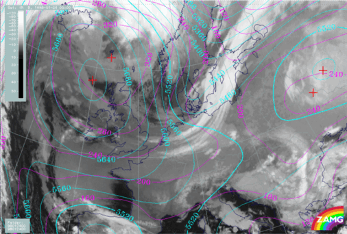
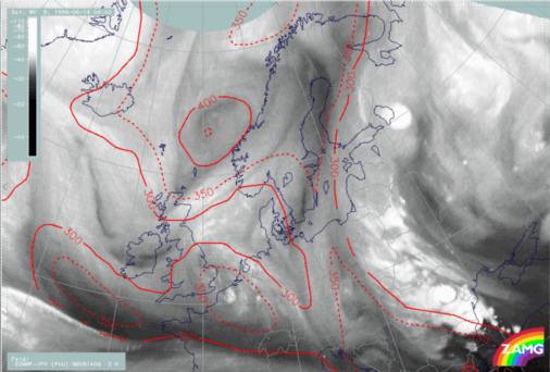
Left: 14 June 1998/06 UTC - WV image; lines: red: height where the
isentropic potential vorticity has two units
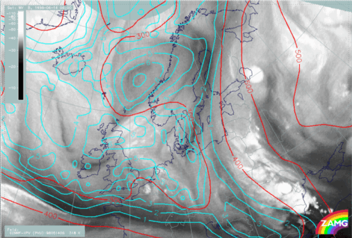
Right: 14 June 1998/06 UTC - WV image; lines: red: isobars, cyan:
isentropic potential vorticity on the isentropic surface of 318 K
|
|
The satellite image shows a developed upper level low above the Norwegian Sea.
The centre of the low can be found at approximately 64°N/01°E. The
height field where the isentropic potential vorticity has 2 units (left image)
shows that the dynamical tropopause within the area of the low extends downward
to approximately 450 hPa. The isentropic potential vorticity field (right image)
is characterized by a pronounced maximum within the area of the upper level low.
 HELP - I AM LOST
 MAIN MENU OF THE MANUAL
SUB-MENU OF THE UPPER LEVEL LOW
MAIN MENU OF THE MANUAL
SUB-MENU OF THE UPPER LEVEL LOW
 FIRST SUB-CHAPTER - CLOUD STRUCTURE IN SATELLITE IMAGE
 THIRD SUB-CHAPTER - KEY PARAMETERS