UPPER LEVEL LOW
written by ZAMG


CLOUD STRUCTURE IN SATELLITE IMAGE
Upper level lows are long-lived phenomena which show a typical life cycle. The
cloud structure of an upper level low in the IR, VIS and WV images is indicative
of the present stage of this life cycle
(compare
meteorological physical background).
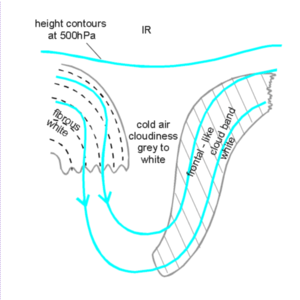
- Upper level trough stage:
This is the stage where a pronounced upper level trough behind a frontal
cloud band still exists. The satellite image shows a well-developed
frontal cloud band at the leading branch of the upper level trough. In
the VIS and IR image this cloud band is white, indicating thick and
multilayered cloudiness. The rearward branch of the upper level trough
might be accompanied by some fibrous cloudiness which normally is
connected to the following warm front. In contrast to the frontal
cloud band these cloud fibres are high level cloudiness and can therefore
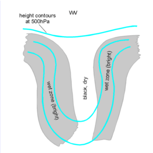
only be seen in the IR and the WV image. The WV image shows two wet zones
(light grey WV bands) which are situated within the leading and rearward
part of the upper level trough. The centre of the trough around the axis
is characterized by dry air, which appears in black in the WV images.
Cold air cloudiness may also exist, but does not show in the WV image.
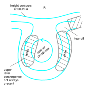
- Tear-off stage:
This is the stage where the upper level trough becomes more and more
pronounced, ultimately to be torn off from the more frontal stream.
Consequently this stage of development is characterized by the frontal
cloud band being torn off in the north-easternmost part of the trough
(area which is called "tear off" in the schematics below). That part of
the frontal cloud band which remains at the leading part of the upper level
trough starts to curve cyclonically. In some cases a cyclonically curved
cloud band develops also at the rearward branch of the upper level trough.
This cloudiness is caused predominantly by convergence within the mid-
and upper levels of the troposphere. This cloudiness appears in the IR
image as light grey to white, while in the VIS image it is dark grey to
grey. The WV image shows a distinct cyclonically curved band of moist
air. Besides the cold air features the centre of the trough is dark grey
to black, indicating dry and sometimes even stratospheric air
(compare
meteorological physical background).
While the cloud structure in the IR image is restricted to the area of
the torn off upper level trough, the WV features extend beyond this
area indicating the humidity sources.
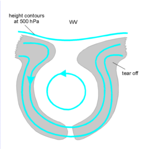
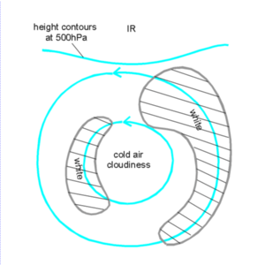
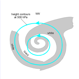
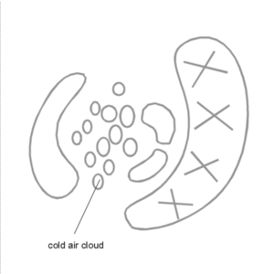
- Cut-off stage:
This is the stage where the former upper level trough has been cut-off
and become a separate upper level low. In the cut-off stage
the cyclonic curvature of both cloud bands becomes stronger. In the WV
image often a cyclonic spiral develops from the edge in the centre of
the upper level low.
As a consequence of the potentially unstable stratification of the troposphere
within the centre of the upper level low, the development of convective cloudiness,
the so-called core convection
(compare
meteorological physical background),
often can be observed. Over sea the cold air cloudiness is very intensive.
Contrary to this, over land often a rather overcast upper level low centre exists
with some cells embedded.
Beside the main cut-off process also secondary cyclonic circulations
develop within the main cyclonic circulation. These secondary cyclonic
circulations have a smaller scale and very often are connected with water vapour
eyes
(compare also chapter WATER VAPOUR EYE
 EY
).
EY
).
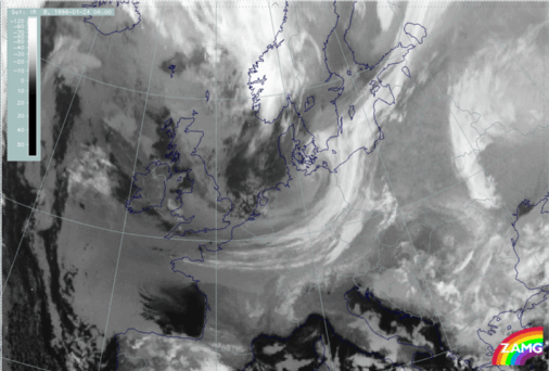
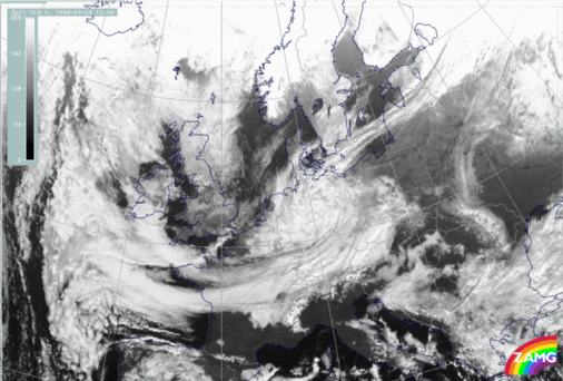
Left: 24 January 1998/00 UTC - IR image
Right: 24 January 1998/00 UTC - WV image
The images above show the first stage of the development of an upper level low,
the upper level trough stage. In the IR as well as in the WV image a cyclonically
curved cloud band can be found within the eastern edge of the trough extending
from Belgium across Germany to the Baltic Sea.
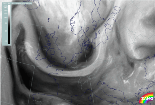
Left: 24 January 1998/06 UTC - IR image
Right: 24 January 1998/06 UTC - WV image
Six hours later the tear-off stage is reached. The IR image (left image) clearly
shows that the cloud band is torn off from the north-eastern situated cloud
band above the south-east coast of Sweden (at approximately 57°N/16°E).
The WV image (right image) shows a moist band extending from the Atlantic across
France, Germany, the Baltic Sea to north-west Russia. Within the area where the
tear-off process takes place the moist cloud band is characterized by a wave
structure. The lower pixel values above south Sweden (at approximately
57°N/15°E) indicate the beginning of cyclonic circulation of the upper
level low.
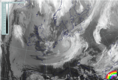
Left: 24 January 1998/12 UTC - IR image
Right: 24 January 1998/12 UTC - WV image
Above left: 24 January 1998/12 UTC - VIS image
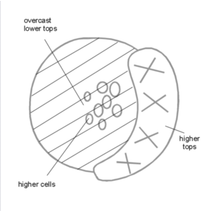
At 12 UTC the upper level low has reached its cut-off stage. The centre of the
low is situated above France at approximately 52°N/11°E. The
cyclonically curved cloud band extending from France across the Czech Republic to
Poland is mostly characterized by high pixel values in all three channels (IR,
WV and VIS images) indicating thick and multilevel cloudiness. In contrast to
this the centre of the low is overcast by mostly low level cloudiness which
appears white in the VIS and grey in the IR image.
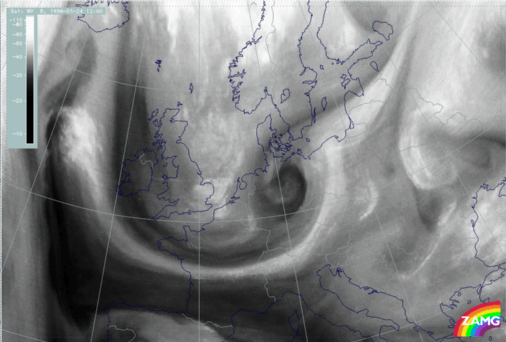
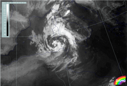
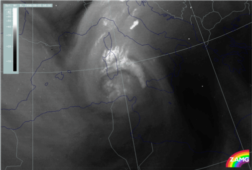
Left: 5 August 1998/06 UTC - IR image
Right: 5 August 1998/12 UTC - VIS image
Above left: 5 August 1998/12 UTC - WV image
The images show a well-developed upper level low which has already reached the
cut-off stage above the Mediterranean Sea between Sardinia and Tunisia. The IR
(left image top) and VIS image (right image top) show a cyclonically curved
cloud spiral extending from Tunisia across the Tyrrhenian Sea and the
Mediterranean Sea to the south coast of Sardinia. Embedded within the frontal
cloud band and in the centre of the low Cb cloudiness (core convection) can be
observed. The centre of the low can best be localized in the WV image above the
Mediterranean Sea at approximately 38°N/09°E). Within this area
cellular cloud clusters can be found in the WV image.
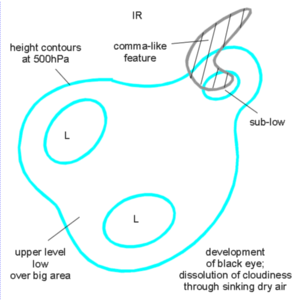
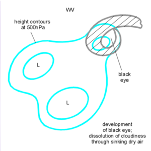
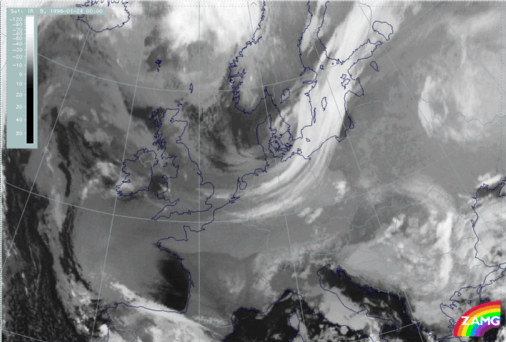
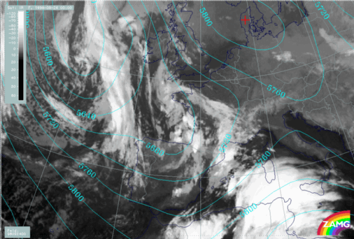
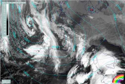
Left: 24 September 1998/00 UTC - IR image; lines: cyan: height contours at 500
hPa
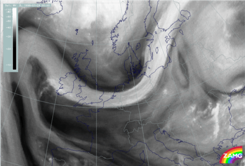
Right: 24 September 1998/06 UTC - IR image; lines: cyan: height contours at
500 hPa
The satellite image at 00 UTC shows the main upper level low above northern Spain
and the west coast of France. The centre of the low, which is also indicated by
the development of convective cells, can be found above the Bay of Biscay at
approximately 44°N/03°W. A secondary cyclonic circulation has developed
at the edge of the main cyclonic circulation above north-west France at
approximately 48°N/04°W).
Six hours later this secondary has moved above south-west England producing
mid-level cloudiness above the English Channel.
 HELP - I AM LOST
 MAIN MENU OF THE MANUAL
-
SUB-MENU OF THE UPPER LEVEL LOW
 SECOND SUB-CHAPTER - METEOROLOGICAL PHYSICAL BACKGROUND
Copyright ZAMG