

|

|
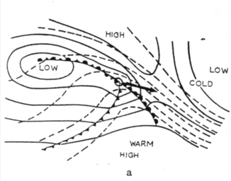
Secondary low in warm occlusion:
The maximum gradient of the temperature is located in front of the occlusion and
the warm front. The secondary low develops at the occlusion point and resembles
the secondary low, which develops at the warm front. When estimating the direction
of the secondary low the 1000 - 500 hPa thickness fields are a useful tool,
according to Sawyer. According to the Sutcliffes development rule the lows are
moving parallel to the thermal wind. The secondary lows move away from the parent
low at about 30 degrees angle (average) to the thermal wind towards the colder air.
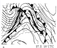
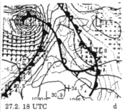
Left: 27 February 1992/18 UTC - weather analysis; lines: isotachs and jet
axis at 300 hPa and height contours at 300 hPa
Right: 27 February 1992/18 UTC - weather analysis; lines: temperature at 500
hPa and height contours at 500 hPa
|
|
|
|
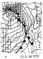
The example of the secondary low in warm occlusion for 27 - 28 February 1992 show
the warm occlusion passing over Finland and the secondary low connected to it
south of lake Ladoga on 27 February 18 UTC.
The secondary low is analyzed on the surface map as a back bent occlusion. The occlusion can be distinguished rather poorly in this stage - it resembles more a new developing wave.
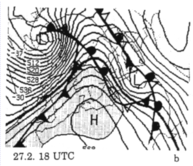
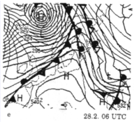
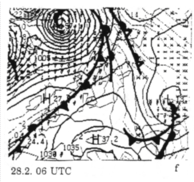
12 hours later:
Left: 28 February 1992/06 UTC - weather analysis; lines: thickness 500/1000
(thin lines) and height contours at 700 hPa
Right: 27 February 1992/18 UTC - weather analysis; symbols: weather events
(rain), lines: temperature at 850 hPa and height contours at 1000 hPa
|
|
In these figures the secondary low has moved fast to the south-east. The old occluded front is almost stationary, and can hardly be seen on the thickness fields of 1000 - 500 hPa.
Secondary low in cold occlusion:
The strongest temperature gradient is located behind the cold front and occlusion.
The temperature gradient in the parent low is weak. The thickness curves
diverge in front of the occlusion point. The secondary lows that develop at the
occlusion point resemble those secondary lows which develop at the cold front.
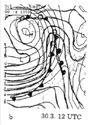
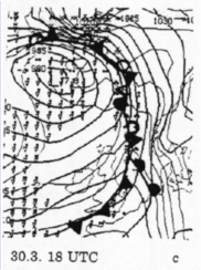
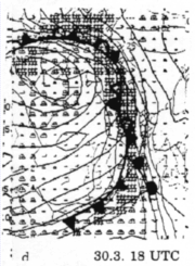
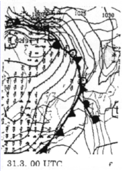
The thickness field around the occlusion point influences essentially the development and direction of the secondary lows. If the thickness curves diverge evenly in front of the occlusion point, as in figure b, the secondary low moves parallel to the maximum thermal wind. Otherwise, if the thickness isolines are diverging unevenly, the movement of secondary low is parallel to the maximum temperature gradient.
Secondary lows connected to a cold occlusion deepen and mature quickly in normal
cases, and therefore their lifetime is short. Furthermore they are small in size,
sometimes there is not necessarily any proper secondary low, but it can be seen as
a weak wave, which moves along the occlusion steered by the thermal wind towards
the centre of the parent low. An example of such a case is presented in the
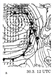
figures below for 30 - 31 March 1993 at six hour intervals beginning 12 UTC.
Left: 30 March 1993/12 UTC - weather analysis; symbols: weather events (rain);
lines: temperature at 850 hPa and height contours at 1000 hPa
Right: 30 March 1993/12 UTC - weather analysis; lines: thickness 500/1000 hPa
(thin lines) and height contours at 700 hPa
|
|
|
|
|
|
30 March 1993 12 UTC: One can observe a wave disturbance in a cold front over
Scotland. This wave developed later into an occlusion wave, which moved steered
by the thermal field to the north along the front. At 18 UTC the wave is seen over
the Norwegian Sea and 12 hours later north-east of Iceland. This situation has
been described based on numerical forecast fields, but in reality the secondary
low, which had a clear surface centre (below 985 hPa), was located on 30 March
12 UTC west of Scotland, and the winds were heavy or even stormy south of the
low. When studying similar synoptic situations it has been observed that the
secondary low develops behind the 1000 - 500 hPa thickness ridge. When the
secondary low develops, the ridge dissolves. There is often an upper level low
in the upper troposphere above the secondary low. The secondary lows, which are
moving along the occlusion do not in general go far from their origin, because
the thermal wind is weak at the occlusion, compared to the area in front of the
occlusion point. Therefore they do not deepen too much either.
14 - 17 August 1998: There was a situation over the area of the British Isles and
Scandinavia which resembled the above-described development of secondary low in
cold occlusion. On the 14th near Scotland a weak wave disturbance developed, which
slowly moved to the north-east. On the afternoon of the 15th the wave was in
southern Norway and the next day in central Scandinavia in the occlusion. This
wave formation could be identified, for instance, in NOAA image for 16 August
14.51 UTC. After that the wave did not move anymore along the occlusion
northwards, but slowly eastwards towards central Finland as a weak discrete
secondary low.
16 August 1998/1451 UTC - RGB image (channel 1, 2 nad 4)

 HELP - I AM LOST
 MAIN MENU OF THE MANUAL