
A comma is a small cloud spiral within the cold air cloudiness at the rear side of fronts, and consists of white (i.e. cold) cloud cells partly overlaid by cirrus shields. Sometimes a comma head, which is the enhanced cloud part, and a comma tail, which consists of much smoother and warmer cloud tops, can be discriminated.
There are different theories for its development:
Typical model parameters for the detection and explanation of the comma conceptual model are upper level parameters like vorticity and vorticity advection. Within a maximum of vorticity advection an enhanced cumulus area develops which then increasingly takes the form of a spiral structure under the influence of cyclonic vorticity.
Another frequently observed but completely different development is the splitting from a highly advanced occlusion spiral. In this case the innermost part of the cloud spiral is torn off and remains as a separate comma structure. Commas with such a development background differ from the classical conditions as they exist under warm advection, which is a remnant of the occlusion process.
The synoptic importance of commas lies on the one hand in the strong weather activity with showers and thunderstorms but also in the various possibilities for further development:

|
|
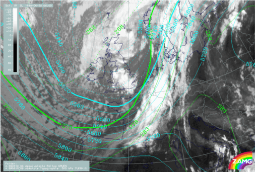
The satellite image shows a comma above the southern part of England. The comma has
a structured appearance which indicates embedded convective cells.
The comma is situated in a trough, immediately in front of the trough axis, of the
height field at 500 hPa and the equivalent thickness (left image).
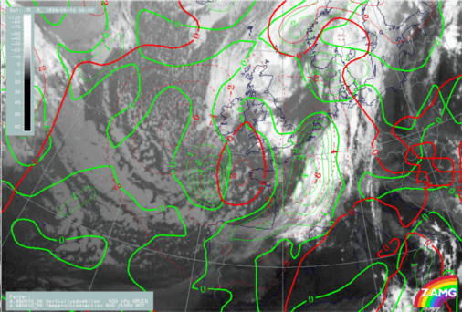
Cold advection and positive vorticity advection can be found within the area of the
comma (right image).
|
|
 HELP - I AM LOST
 MAIN MENU OF THE MANUAL